Mountain Kilimanjaro National Park, Kilimanjaro Mountain hiking Safari Tanzania Tour, Tanzania Mountain Climbing Safaris Tour, Tanzania Safari Excursions.
With three extinct volcanic cones on the most distinctive feature in the park which is Mt.Kilimanjaro, the national park lies in the Northeast of Tanzania along the border with Kenya near Moshi city and is about 300Km south of the equator.
It’s the most popular and most visited National Park in Tanzania covering a total surface area of about 652Km².
Historically, the area of the park was gazzeted in 1921 as a game reserve together with its adjacent forests by the German colonists.
Mt.Kilimanjaro was however declared a national park in 1973 and was open for public access in 1977.The National park covers a total area of about 753Km² and is surrounded by its adjacent forest, Biome forest which covers a total area of about 1078Km².
Due to the parks proximity to the equator, the park experiences temperatures around 27 to 32°C at the lower elevation and -18 to -26°C towards the summits.
Temperature is determined by altitudinal changes, decreasing by 1 degree every 200 meters altitude increase.
The driest months are August to October. The area has two rain seasons that run from March to May and November to December; with annual rainfall of about 3000m.
However, rainfall is determined by altitude and side of the mountain. The northern side is drier than the southernside.
Kilimanjaro Nationalpark is characterized by five vegetation zones which include the montane forest, savanna bush land, sub alpine moorland, alpine desert and alpine bogs.

Safari Attractions in Kilimanjaro National Park
Mt.Kilimanjaro
 The mountain is primarily the highest in Africa and the highest freestanding volcano in the world with an altitude of 5,895m above sea level.
Mt.Kilimanjaro is an extinct volcano with three cones namely; Mawenzi, Shira and Kibo.Mt. Kilimanjaro was formed about 750 thousand years ago by volcanic activity.
The 3 cones of the mountain grew over years and shira collapsed into a caldera becoming extinct about 500 thousand years ago.
Mawenzi and Kibo continued to grow with lava increasing lava that gave them a height reaching 5,500m. Mawenzi however eroded and became inactive eventually.
Kibo continued to grow due to a continuous lava flow, with extensive eruptions about 360 thousand years ago that produced black lava known as Rhomb porphyry, embedded with diamond shaped crystals.
The growth of the mountain is believed to have ceased about 450 thousand years ago with Kibo at approximately 5,900m altitude.
However, though the elevation began to shrink due to global changes, eruptions intermittently continued and during the extinct times, erosion sculpted the mountain forming the peaks of Mawenzi and the gentle plateau of shira.
Kibo finally had its last volcanic activity forming the present caldera. When glaciers occurred on the mountain, vegetation such as montane forest grew on the well watered slopes lower slopes.
Currently, Mt.Kilimanjaro is a snow caped mountain looming over the plains of the Savannah. The mountain is divided into 5 climatic zones each with different wildlife and vegetation.
At the base of the mountain, there is a dominance of evergreen montane forest which transforms into a shrub land setting at approximately 3,000m.
The mountain becomes arid and rocky at around 4,000m. Above 4,000m the mountain has a fine glacial scree. At the summit, there are partially snow-capped large glaciers intercepted.
Wildlife in Mount Kilimanjaro National Park
The park has a wide variety of wildlife totaling to about 140 mammal species with 87 species endemic to the forest. Out of the total species of mammals, 25 are carnivores, 25 antelopes and 25 are bat species. They include Cape buffalo, red duiker, elephant, leopard, bushbuck, blue monkey, grey duiker and many others.
Birds in Mount Kilimanjaro National Park
 A collective judgment of scientists has it that birds are of dinosaur’s origin.
They share features such as hollow pneumatizes bones, nest building and incubation behaviors.
Bird species are the reason as to why Airplanes exist. Some scholars assert that birds were created out of extreme engineering, due to their capability to fly using a system of feathers.
For years, humans admired how birds flew in the air, being able to view the world below them up in the sky.
This forced humans to put their brains at work and start thinking of how to get themselves up in the clouds just like the birds. Men and women did their best to try navigating air by imitating the birds. However, in the 19th century, an English baronet; George Cayley made a flying machine with fixed wings in 1799.
This marked the begging of airplane evolution. Some of the common birds in the park include Mountain greenbul, African harrier hawk, Giant Kingfisher, Green pigeon, Cinnamon chested bee eater, crowned hornbill and others; Rare species such as handsome francolin, Regal sunbird, short tailed warbler and many others.
Black and White Colobus monkey
 The primate species is an Old World Monkey of the Colobus genus which is native to Africa.
They are named Colobus because they don’t have a thumb.
The word colobus is derived from a Greek word ‘Kolobos’ which means docked.
The species are herbivorous and have a ruminant kind of digestive system i.e. they feed on leaves, fruit, flowers and twigs. Black and white colobus monkeys are endemic in higher density logged forests.
However, they also live in riverine forests and wood grassland. Being herbivorous, black and white colobus monkeys are of importance to their habitant because of seed dispersal which causes germination of seeds into plantations hence expansion of vegetation in the Park.
This is because of their sloppy eating habits. The species live in social groups of up to 9 members with a dominant male, females and offspring’s. Newborns are completely white and are taken care of by only the mother.
Vegetation in Mount Kilimanjaro National Park
The park has five main vegetation zones which include montane forest, savanna bush land, sub alpine moorland, alpine desert and alpine bogs.
- At the base of the mountain, there is a sub-montane agro forest which is intercepted by densely populated farmlands to the south and south east of the park.
- At an elevation between 700 to 1000m, there is the savanna bushland on the southern side; and between 1400 to 1600m on the Northern side of Kilimanjaro Mountain.
- The savanna bush land is intercepted by a montane rainforest which runs from about 1,300 to 2800m on the southern side; and from 1600 on the northern side of the Mountain.
- Above 2800m is the sub alpine moorland zone which runs up to 4000m. It is characterized by heath and moorland.
- Above 4000m lies the alpine desert which is bounded by the glaciers at higher elevation.
Communities in Mountain Kilimanjaro National Park
Masaai Community
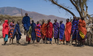 The tribe belongs to the Nilo-saharan ethnic group and is believed to have migrated from Ethiopia in 1600 A.D.
They split into two groups, one group that had the Kalenji and Masaai of Kenya and Tanzania; and the second group known as Ateker which migrated westwards and further split into Turkana of Kenya; Iteso, Dodoth, Jie and karamajongs of Uganda.
Massai are mainly large herd cattle keepers, moving from place to place in search of pasture and water for their cattle.
This is because of the un-favorable semi-arid climate in thei areas of settlement which doesn’t allow growth of plenty of vegetation, and availability of water.
The Masaai are one of the most popular African ethnic tribes due to its distinctive customs, settlement near most of the East African games parks and distinctive attire.
They speak Maa language and are also fluent in Swahili, which is the National language of Tanzania. Masai society comprises of six sections which include IIdamat, IIkeekonyokie, IIkaputiei, IIarusa, Kore, Parakuyu, llkankere, IIoodokilani and Tanzania’s Isikirari.
The Maasai live in Kraals made out of acacia thorns, preventing carnivorous mammals like lions from attacking them and their cattle.
They move 3 – 4 months every year away from their homes to neighboring districts hoping to find pasture and water for their animals.
Any male to be regarded a man, as well as a requirement of engagement; he is required to wrestle the woman he desires to marry.
If he wins the match, he is eligible to marry her and dowry negotiations are allowed to begin; but if he loses the match, he is considered weak and can’t be able to take care of her. He will also be barred from getting any female in the community.
Women carry out most of the activities which are related to permanent settlements. With the exception of some milk products; food consumed only in permanent settlements is generally the product of women’s agricultural efforts.
The staple crop grown is sorghum, which is planted with cucumbers and marrows. Other crops cultivated include beans, gourds, maize and millet.
Men primarily carry out cattle herding which involves attaining milk and blood which is drunk as a food supplement.
Cattle are literally wealth; they are used to establish families, acquire political supporters, achieve status, and influence public affairs.
Cattle is also used as bride price paid to girl’s family, as an essential step to arranging a marriage.
Activities in Kilimanjaro National Park
Mountain Hiking
DIFFERENT ROUTES TO TAKE WHILE HIKING MOUNTAIN KILIMANJARO
Marangu Route
Day 1: Marangu to Mandara Hut
The gate is at an altitude of about 1,600m, starting the hike through a rainforest and lush forest to Mandara Hut which is at 2,700m.
The trail from Marangu to Mandara hut lasts about 4hrs at a steady pace. Close to the Mandara hut is the Maundicrater lake which is just above the forest.
While at the Mandara hut, there is view of the Mawenzi in clear weather; which is the lower of the two main peaks of Kilimanjaro.Total time: 4hrs
Day 2: Mandara to Horombo Hut
The hike commences as early as 9am, hiking through the remaining area of the rainforest which lasts about 30min; and emerging into alpine moorland at about 3,700m where the Horombo hut is situated.
The walk lasts for a minimum of 7 hours and on clear days there are magnificent views of the Kibo and Mawenzi summits.
The vegetation at the altitude is composed of heather, protea, lobelia, giant groudsel, redhot pokers, everlasting flowers and other vegetation.Total Time 7hrs
Day 3: Horombo to Kibo Hut
From Horombo hut there are two routes which lead to the Kibo hut,the upper and lower routes. The upper route is the older among the tworoutes to Kibo from Horombo hut.
The route heads up on a steep hill to the foot of Mawenzi, climbing about 600m from Horombo hut. It then descends into the high altitude desert between Kibo and Mawenzi known as the saddle.
The route goes further climbs gently uphill about an hour before reaching Kibo hut and at this pont the elevaton is about 4,700m.
The lower path leads directly towards the Kibo hut from Horombo. The path is shorter but not adventurous like the upper route.Total time: 6 to 8Hrs.
Day 4: Kibo Hut to Summit
The hike starts at midnight and requires warm clothing. The hike heads to the Hans meyer Cave, going around a large rock which is not steep as the latter.
Past the cave, the path begins to move in a zigzag fashion 6hrs climbing up a steep hill to the Gillmans’s point which is at an elevation of 5,700m.
The hike commences in the morning with views of the sun on a clear day, from the Gillman’s point. The path leads around a crater rim to a one and a half or 2hrs hike to the Uhuru summit which stands at 5896m.Total Time: 8Hrs
Day 5: Descending to Mandara Hut
The descent to the Mandara hut takes about 3Hrs and 2Hrs to the Marangu gate.
Machame Route
Day 1: Machame gate to Machame Camp
The hike begins at an elevation of 1,800m through the rainforest which lasts about 5 to 6 hrs, gradually ascending through the lush forest and a ridge, between two streams onwards to the camp which at an elevation 3,000m.Total Time: 5 to 6hrs
Day 2: Machame to Shira hut
The trail moves through a steep ridge from Muchame camp through a moorland that is present until 3600m after a four hours hike.
The path moves further out into the gorge and ascends more gradually to shira camp at 3840m on the shira plateau west of kibo.Hike Time 5 to 6Hrs.
Day 3: Shira to Barranco hut
The route moves up hill up to the lava tower after a four hours hike, at the foot of the the great western breach.
It crosses the breach and descends into the barranco gorge where the Barranco camp is situated at 3950m.Total Time: 5 to 6Hrs
Day 4: Barranco to Barafu Camp
The hike begins with a 1 to 2hrs steep climb via the barranco wall ascending about 300m, and follows a gentle slope to the Kibo south circuit.
While going through the Kibo circuit, there is a magnificent view of the southern glaciers on a clear day. The hike continues 3hrs on a steep descent hill into the valley which has a small stream to an eastern valley wall where the Karanga valley camp is situated at 4000m.
Usually, lunch is had at this point and during the 1hrs rest. The hike continues up to Barafu camp which is about 3Hrs from karanga valley camp.Total Time 7 to 8Hrs
Day 5: Barafu Camp to summit
The hike begins at midnight and requires warm clothing. The first part of the hike is on a rocky ridge which could be loose and can be hard going.
The path then turns out to be in a zigzag fashion up the scree. The hike takes 7Hrs to reach stella point which is at an elevation of 5750m on the crater rim.
While at the stella point, there is a magnificent view of the sun as it rises behind Mawenzi. From the stella point, the route goes around the crater rim for about 1hr to the summit at Uhuru peak which is at 5896m.
From the summit, descending back to the Barafu camp lasts for about 4hrs. If the hikers are tired, camping can be done at the Millennium camp which is at an elevation of 3800m.
The difference is that it increases the descending timeby an hour. Descending continues to Mweka camp which is at 3100m, lasting for about 4hrs.
Day 6: Mweka Camp to Mweka gate
The route descends down through a rainforest to mweka gate, lasting about 3hours.
Optional day 7: An extra night stop can be made at the Karanga Valley camp prior to the summit attempt, making it to two relaxing days.
Lemosho/Shira Route
Day 1: Londorossi gate to MtiMkubwa Hut
Ascending up the mountain begins at the gate which is at 2000m altitude through a steep rainforest to Lemosho glades which is at 2200m and finally to MtiMukubwa hut at 2800m.Total Time 5Hrs
Day 2: MtiMukubwa to Shira 1 hut
The hike goes above the forest to the moorland which is about an hour from MtiMukubwa. Ascending continues northwards around the shira ridge through a beautiful rugged moorland with a magnificent scenery of the northwards and westwards plains below the mountain.
The path proceeds eastwards and drops down onto the shira plateau where the Shiraht is situated at an elevation of 3,500m. Total time 6 to 7Hrs
Day 3: Shira 1 to Shira 2 hut
Hiking continues across a plateau towards Kibo and after 2hrs, the edge of the plateau is reached climbing up for about 40 minutes to shira hut at 3800m.
The route allows hiking to the shira cathedral and shira needle. The two are imposing hills on the southern side of the plateau, with a magnificent view of the Machame ridge below the plateau.
Further exploration in the area can be made to the cone place which is the center of the shira extinct volcano. Total Time 4hrs.
Day 4: Shira 2 to Barranco Hut
The hike involves exploration of the lava tower which is at 4600m, about a 4hrs hike from Shira 2. The path proceeds to the right and descends into Umbwe valley which is also known as Barranco Valley at an elevation of 3985m. Total time 6 to 7Hrs
Day 5: Barranco to Barafu Hut
Ascending between the two points involves hiking about 300m on a steep hill for about 2hrs. The path follows the Kibo south circuit where there a breathtaking views of the glaciers at the kiboif the weather is clear.
The hike continues at the eastern valley wall, and further up at 4000m is the karanga valley hut. There is a lunch time break at the karanga hut, and the hike continues up to the Barafu hut which is about 3hrs from the karanga valley hut.Barafu hut is at an elevation of 4600m. Total Time 7 to 8Hrs
Day 6: Barafu Camp to the summit
The hike starts at midnight and requires warm clothing. It begins on a loose surface rocky ridge and the path turns into a zigzag format on a steep scree to the Stella point at the crater rim which is 7Hrs from Barafu hut.
While at the stella point, the sun is seen rise in the morning behind Mawenzias the hike proceeds 1Hr towards Uhuru peak at5896m.
From Uhuru peak, a descent back to the Barafu hut which lasts for about 3 to 4Hrs. After a meal and resting at Brafu hut, descending continues down to Mweka hut at 3100m altitude which is 4hrs away.
If the trekkers are tired or when its too late, camping could be done at Millennium camp which is at an elevation of 3800m.
However, taking the alternative increases the length of the following day by an hour.Total Time: 15Hrs
Day 7: Mweka hut to Mweka gate
Descending to the Mweka gate through the rainforest lasts for about 3hrs
Day 8: Optional day
The optional 8th day is suitable at Karanga valley after a long day hike prior to the summit attempt the following day.
Rongai Route
Day 1: Nalemuru gate to Simba hut
The route explores the mountain from the north side, starting the hike at the Nalemuru gate which is at an elevation of 2200m.
The hike goes through a forest for about 3 to 4 hrs gradually ascending to the Simba camp which is at 2600m. Total Time 3-4hrs
Day 2: Simba to Kikelewa hut
The hike continues 3hrs up through a path of alpine moorland to a cave which is at 3500m. While at the cave, there is resting and lunch served.
After the lunch break, the hike proceeds on a rocky path up to kikelewa cave which is at an elevation of 3690m. The trek is quite long since most of the altitude is covered in the first half of the day. Total time: 6 to 7Hrs
Day 3: Kikelewa to Mawenzihut
The trek climbs up a steep altitude at the top of the ridge and turns left across a rocky landscape that descends into a tarn valley where the Mawenzi camp is situated at about 4320m altitude.
The distance between the two points is about 5Km, but covering the distance in a short time becomes difficulty due to the steepness of the area.Total Time 3 to 4Hrs
Day 4: Mawenzi to Kibo Hut
The path between the two huts traces the route of the previous day for a short distance, then descends into a saddle which is between the two huts.
From the saddle, there is a 6Km ascending through a high altitude desert to Kibo hut which is at an elevation of 4700m.Total Time 5 to 6Hrs.
Day 5: Kibo Hut to Summit, descending to Horombo Hut
The hike begins at midnight and requires warm clothing. Hiking will go round a large rock to the Hans Meyer Cave which is not as steep as the previous hike.
The surface at this point is loose and could be slipperly. Past the cave, the hike becomes extremely steep which makes it difficult to hike directly.
Therefore, a zigzag hiking format is used to ascend up to the Gillman’s point which is on a crater rim at an elevation of 5700m.
The hike to this point lasts for about 6Hrs. By the time you reach the Gillman’s point, you will be able to witness the sun as it rises behind Mawenzi in the morning.
The path continues around the crater rim to the summit of Uhuru peak which is about 1Hr 30min from Gillman’s point.
From the Uhurupeakwhich is at an elevation of 5896m, descending will begin to the Kibo hut which is about 3 to 4hrs away from the Uhuru peak.
There is a breakfast break at the Kibo hut and then descending continues to the Horombo hut via the lower route lasting for 3hrs.Total Time: 14hrs
Day 6:Horombo hut to Nalemuru gate
The descent goes down to Mandara hut which is 3hrs away, and later through the rainforest to the Nalemuru gate. The descent lasts for a about 2Hrs from Mandara hut to the gate. Total Time
Alternative: The Rongai route can last for a minimum of 5 days rather than 6 days if desired. In order to complete the hike in 5days, the Mawenzi hut is not visited, and on the second day the route taken directly leads to the Kibo hut.
Umbwe Route
Day 1: Umbwe gate to Forest Camp
From the Umbwe gate which is at an elevation of 1800m, ascending through a lush rainforest at a steep elevation and finally at the forest camp which is about 5 to 6 hrs away.
Day 2: Forest Camp to Barranco hut.
The hike continues up on a steep side of the Umbwe valley emerging from the forest where there is a brilliant view of the Kibo peak up the mountain and the Umbwe valley below, which is the largest valley on the slopes of Kibo.
Ascending continues up to the western flank of the valley to Barranco hut which is at 3950m. The entire hike is very tiresome and lasts for about 6to 7Hrs.
Day 3: Barraco to Karanga Valley
Ascending between the two points involves hiking about 300m on a steep hill for about 2hrs. The path follows the Kibo south circuit where there a breathtaking views of the glaciers at the kibo if the weather is clear. The hike continues at the eastern valley wall, and further up at 4000m is the karanga valley hut.Total Time: 3hrs
Day 4: Karanga Valley to Barafu hut
The hike between the two points is lasts for 3Hrs up to an elevation of 4600m where Barafu hut is situated.
Day 5: Barafu hut to Summit
The hike starts at midnight and requires warm clothing. It begins on a loose surface rocky ridge and the path turns into a zigzag format on a steep scree to the Stella point at the crater rim which is 7Hrs from Barafu hut.
While at the stella point, the sun is seen rise in the morning behind Mawenzi as the hike proceeds 1Hr towards Uhuru peak at 5896m.
From Uhuru peak, a descent back to the Barafu hut which lasts for about 3 to 4Hrs. After a meal and resting at Brafu hut, descending continues down to Mweka hut at 3100m altitude which is 4hrs away.
If the trekkers are tired or when its too late, camping could be done at Millennium camp which is at an elevation of 3800m.
However, taking the alternative increases the length of the following day by an hour. Total Time: 15Hrs
Day 6: Mweka Camp to mweka gate
Descending to the Mweka gate through the rainforest lasts for about 3hrs.
Accommodation in Kilimanjaro National Park
Upscale
Salsalinero Hotel
The hotel has 30 en-suite unit rooms and has facilities such as swimming pool, Wi-Fi, conference room, bar and restaurant.
| ROOM | Bed & Break Fast | Half Board | Full Board |
| Single | 112 | 139 | 160 |
| Double | 171 | 193 | 214 |
| Tripple | 214 | 246 | 278 |
| Executive suite | 246 | 267 | 289 |
- NB: All rates are based in US$
- Only children under 6 years are charged 50% of the Adult rate. 3yrs and below are not charged
- Extra breakfast is charged $12 and lunch $15
KIA Lodge
The lodge is located only 5minutes drive from Kilimanjaro Airport. KIA lodge has 40 spacious African style thatched brick en-suite cottages with a private setting of beautiful savanna gardens.
All the cottages have twin 0r double beds, ceiling fan and safe mosquito nets. It has facilities such as restaurant which serves continental, international and African cuisine dishes; open bar with a lounge area where the magnificent Kilimanjaro Mountain can be viewed; curio and Tanzania shops; free Wi-Fi; and hilltop swimming pool with outstanding panaromic views of Mt.Kilimanjaro.
Kambi Ya Tembo Camp
The camp has 14 tents each with an en-suite bathroom. The camp has facilities such as a dinning area, lounge, evening entertainment by the masai people
Midrange
Park View Inn
The lodge is located in Moshi, 40Km away from Kilimanjaro international airport. The Inn has a total of 44 en-suite rooms that range from deluxe doubles, singles and junior suites.
All rooms have facilities such as safety deposit box, mini refrigerator, complimentary Wi-Fi access, telephones and cable Television. Other facilities at the Inn include a swimming pool and restaurant.
| ROOM | Non-Resident US$ | EAC Resident Tsh. |
| Single | 75 | 75,000 |
| Double Deluxe | 85 | 85,000 |
| Junior Suite | 120 | 120,000 |
NB: All rates are on a Bed and Breakfast plan

Over 300 excellent reviews on TripAdvisor
Over 50 excellent reviews on Safaribookings.
Over 50 excellent reviews on Safaribookings.
12+ years of experience.
Best price guarantee.

Robert
Seek the expertise of a dedicated safari specialist for expert guidance and advice...
Whether you're seeking top-notch safari advice or in need of expert guidance, feel free to contact us via phone or schedule a video conference with our specialists.